Thinking Like a Gulch: Pacific War Heritage, Settler Lands, and Subsurface Toxic Uncertainties in Oʻahu
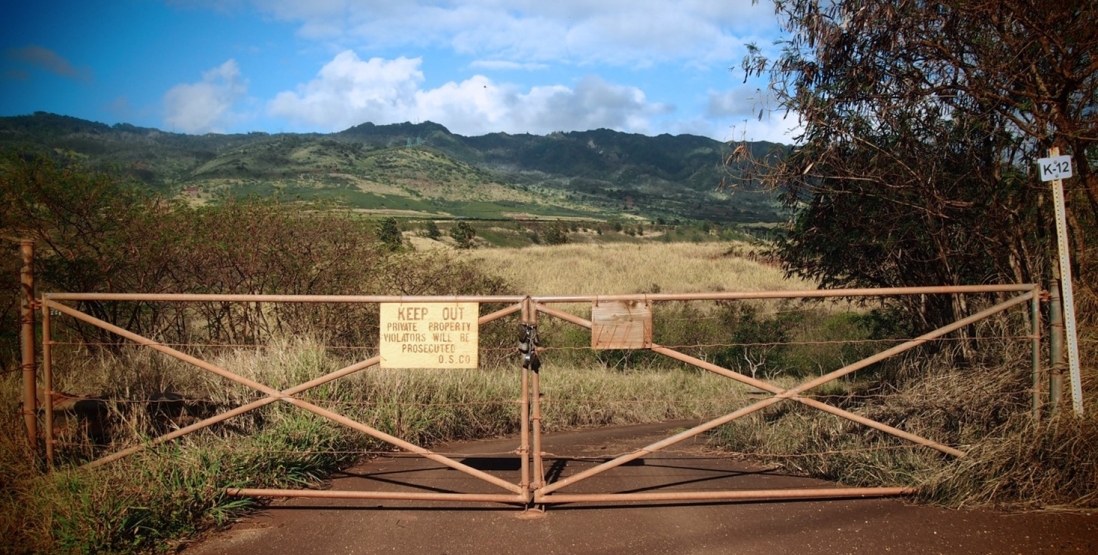
“Keep Out Private Property Violators Will Be Prosecuted.” Hand-lettered sign on yellow padlocked gate leading to Honouliuli National Monument, O‘ahu, Hawai‘i, 2017.
Photo by the author, initial site visit, 2017.“Honouliuli” is an ʻŌlelo Hawaiʻi word meaning rich lowland, and it refers to a 43,000-acre ahupuaʻa, or traditional land and water division in the central plains of Oʻahu, Hawaiʻi. Honouliuli’s unstable grounds and contested land claims are concealed in this gulch, which was a sugar plantation, then a World War II prisoner-of-war (POW) and civilian internment camp. Today, this gulch landscape is enshrined as the 122.5-acre Honouliuli National Historic Site.
Honouliuli’s partially submerged grounds bring together multiscalar geographies, settler-colonial histories, and uncertain toxic sedimentation.1 To surface Honouliuli’s landscape history, I draw from a body of scholarship that constitutes the “volumetric turn”—a scholarly discourse in political geography that considers space in three-dimensional terms, with complex heights and depths, instead of as a horizontal, fixed, terrestrial surface.2 Thinking volumetrically draws attention to the gulch’s uneven or lumpy topography and the processes of accretion and accumulation in soil, and offers a dynamic way to reconceive of this gulch landscape’s broader connection to the watershed. This way of thinking about unstable grounds can allow for creative speculation of toxic histories of Hawaiʻi’s gulches and watersheds that remain intimately connected to plantation and agrochemical seed industries. A subterranean or sedimentary optic can lift submerged perspectives and “unground” colonial ideas and practices about hidden, obscured, and below-ground ecosystems.3 In sum, thinking like a gulch through these volumetric imaginaries reveals how settler jurisdiction and toxic sedimentation are managed, represented, and tamed under the rubric of historic preservation. The following sections of this experimental piece focus on a series of encounters in the gulch and processes of sedimentation, burial, and recovery.
The Gulch: Sinks and Spills
The gulch is a common topographic feature in Hawaiʻi. To a geologist, a gulch is a deep divide or precipitous cleft in the land, smaller than a ravine but larger than a gully, with a dry creek bed or an active creek, which in the occasional downpour may quickly become a conduit for dangerous flash flooding. A gulch’s sunken topography and hollow, V-shaped valley are formed by gradual erosion. The etymology of the word emphasizes the feature’s role as a transportation corridor and a passageway. “Gulch” originates from the Middle English dialectical verb gulsh, meaning “sink in” (of land) or “gush out” (of water), and from the now obsolete Middle English gulchen, meaning “to gush out or gush forth” or “to gulp greedily.”
As a ubiquitous feature of the Hawaiian landscape, the gulch plays a prominent role in contemporary Hawaiian poetry. In her 2017 poem “Water Remembers,” poet and academic Brandy Nālani McDougall (Kanaka ʻŌiwi with Hawaiʻi, Maui, and Kauaʻi lineages) writes,
Each year as heavy rainfalls flood the valleys,
pill over gulches, slide the foundations
of overpriced houses, invade sewage pipes
and send brown water runoff to the ocean,
the king tides roll in, higher in its warming,
lingering longer and breaking through
sandbags and barricades, eroding the resorts.4
She charts the path of runoff that transgresses borders and boundaries, drawing attention to overflows of water channeled through Hawaiʻi’s gulches and into the ocean following storm surge events as it “spills,” “slides,” “invades,” “lingers,” “breaks through,” and “erodes” infrastructures across the island. Her poem reveals how the flows of water, facilitated by gulches, have the capacity to not only nourish, sustain, and nurture but also to destroy.
Cathy Song, an Asian American poet from Hawaiʻi, also features the gulch as an important landscape formation in her poem “Leaving” (1983), in which she evocatively describes the landscape of central Oʻahu’s plantation fields in Wahiawa (located slightly north of Honouliuli). She writes,
Wahiawa is still
a red dirt town
where the sticky smell
of pineapples
being lopped off
in the low-lying fields
rises to mix
with the minty leaves
of eucalyptus
in the bordering gulch.
We lived there
near the edge.5
Song describes the gulch in her poem as a sink, a border, or an edge condition. Overgrown with eucalyptus, a widespread invasive species on the island, the gulch is a vestige of plantation irrigation infrastructure in the region.
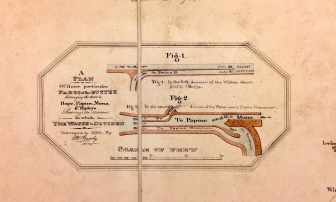
In both McDougall’s and Song’s poems, the gulch is a commonplace feature that harkens to Kingdom Era Hawaiʻi (1795–1874), when Kānaka Maoli (Native Hawaiians) used a combination of terraced fields and impervious clay gulches to redirect water to irrigate lands through selective flooding (fig. 1).
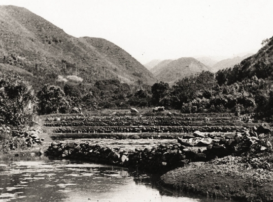
Fig. 1. Hawaiian irrigation systems involved channeling water into ʻauwai, or hand-dug ditches, to grow kalo (taro) in the agricultural fields.
“Oahu’s Water History,” Board of Water Supply.
In the nineteenth century, foreign investment in ranching activities, cane fields, and sugar mills in central Oʻahu depended on existing Hawaiian irrigation infrastructure. Sugar economics associated with Hawaiʻi’s export-based plantation system profoundly altered Hawaiian water rights, agricultural practices, and land division systems such as the ahupuaʻa, a traditional Hawaiian subdivision that consisted of watershed units shaped by the island’s topography.6 Between 1856 and 1920, a complex system of gulches, aqueducts, ditches, and pipes worked in tandem to transport over eight hundred million gallons of water a day, all diverted from streams and mountain areas.7 Gravity drove these networks, which redistributed the island’s freshwater supply to Oʻahu’s plantations in the central plains.
Since the 1980s, the agrochemical seed industry has supplanted sugar as the dominant agricultural sector in Hawaiʻi. This newer industry accounts for 45 percent of the value of Hawaiʻi’s agricultural commodities and nearly 25 percent of agricultural jobs as of 2009. Agribusiness giants such as Monsanto and Mycogen set out to make use of the year-round growing season and agribusiness-friendly politics and began to retrofit aging agricultural infrastructure such as aqueducts and gulches to grow genetically modified crops for export to the US mainland (this practice was banned in Hawaiʻi in 2013).8
Given the pivot to genetically engineered crops in the mid-1990s, gulches and their associated watersheds are now alleged to contain a variety of toxic or otherwise hazardous substances, including residues from chemical fertilizers, herbicides, and pesticides. In addition, contaminants from US Navy activities spill into these watersheds, as evidenced by the Red Hill Fuel Storage Facility leak, which in 2021 sent over 180,000 gallons of petroleum into the aquifer that provides drinking water for over 400,000 residents and visitors, from Hālawa to Hawaiʻi Kai.9
So, what drains in and out of the Honouliuli Gulch today? How do we understand the invisible, the inanimate, and the more-than-human forms that reside as afterlives of the gulch? This story of the Honouliuli Gulch landscape cannot simply be narrated solely through its performance metrics or resource economics: its water output, surface runoff, and carrying capacity. Instead, the networked spatialities of this gulch demand attention to the broader complexities of land and power that have encroached on this Indigenous ahupuaʻa and fundamentally transformed the Honouliuli Gulch. Given that the environmental history and geographies of the Honouliuli Gulch are expansive, this drainage ditch cannot be easily disentangled from the ecosystems to which it is so intimately connected. As both an infrastructure and ecology, Honouliuli Gulch is a punctuated and discontinuous geography with multidirectional and multiscalar flows that defy settler borders, boundaries, and jurisdiction.
The Entry: Unlikely Antiquities
Fig. 2. “Keep Out Private Property Violators Will Be Prosecuted.” Hand-lettered sign on yellow padlocked gate leading to Honouliuli National Monument, O‘ahu, Hawai‘i, 2017.
Photo by author, initial site visit, 2017.
“Take the back roads!” we are instructed. It is the end of May 2018. I am one of fifteen participants enrolled in a six-week forensic anthropology summer field school offered annually, since 2012, by the University of Hawaiʻi West Oʻahu (UHWO) in partnership with the National Park Service (NPS). With me are aspiring landscape archaeologists and forensic anthropologists who traverse a long track into the bowl of an overgrown, concave landscape. We are roughly six miles mauka (inland) from the Oʻahu coast at the foothills of the Waiʻanae Mountains, sloping toward Pearl Harbor. We enter through three sets of yellow padlocked gates and an agricultural fence propped up by wooden signposts blaring, “NO TRESPASSING,” “FEDERAL PROPERTY,” “NO ACCESS TO PUBLIC LAND,” “KEEP OUT! PRIVATE PROPERTY. VIOLATORS WILL BE PROSECUTED” (fig. 2).
This land was once the site of Hawaiʻi’s largest and longest-running POW and civilian internment camp, which was in operation between 1943 and 1946, interning a population of approximately four hundred civilian internees and four thousand POWs. This secluded location was chosen to conform to the rules set by the Geneva Convention for the treatment of captured enemy aliens. The Honouliuli Prisoner-of-War and Civilian Internment Camp’s diverse population included American citizens, resident immigrants, other civilians, enemy soldiers, and labor conscripts from Asia and the Pacific.
Honouliuli’s civilian internees were predominantly civilians of Japanese descent who lived in what was then the Territory of Hawaiʻi. Most were incarcerated on suspicion of disloyalty. These civilian internees nicknamed the gulch Jigoku-Dani, or Hell Valley, to describe the trapped heat and moisture and to convey their sense of isolation and unjust confinement.10 The remaining groups of civilian internees included German Americans in addition to Americans of Italian, Irish, Russian, and Scandinavian descent. The four thousand POWs in Honouliuli included enemy soldiers and labor conscripts from Japan, Korea, Okinawa, Taiwan, and Italy, in addition to noncombatant women and children displaced from the Pacific region. The varied POW compounds (fig. 3) were guarded by an infantry unit of Black troops.11
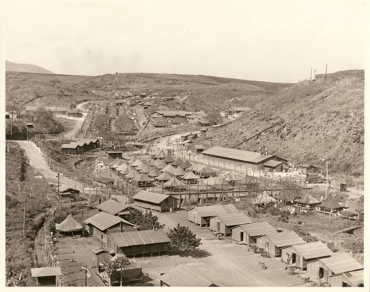
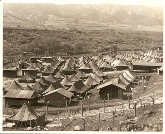
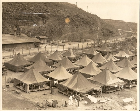
Fig. 3. Architectural typologies at Honouliuli Internment Camp 1943–1946, Compounds VI and V. From top to bottom: semi-permanent barracks in the administration area; temporary pyramidal tents and barracks in POW compounds; semi-permanent barracks in the civilian internment area; and shaded tents on platforms.
Folder 4, Box 2: Honouliuli, UHWO Archives.
Today, these complex racial, spatial, and political dynamics are obscured. At first glance, all that remains are the subsurface remnants and partially submerged residues of a World War II–era military installation in the Pacific Basin. Overgrown invasive species such as Guinea grass and haole koa further conceal this floodplain. Drainage infrastructure, built prior to the war, attests to the site’s use as a ditch for nearby sugar plantations and its continued functioning for its most recent landholder, Monsanto, which used these lands to harvest genetically modified corn. To a careful observer, cracked concrete foundations, watchtower footings, rusty rebar, mortared retaining walls, and stone edging hint at traces of a former US Army compound.
In 2015, the grounds of Honouliuli were deemed an “antiquity” and “an object of archaeological interest” for their significance as a World War II POW and civilian internment camp.12 Former US president Barack Obama designated 122.5 acres of this region in his home state of Hawaiʻi as a national monument. He did so by using the executive powers of the Antiquities Act of 1906, which is a hallmark of US federal preservation law that allows a president to unilaterally declare sites of historic natural or cultural interest through presidential proclamation without congressional approval.13
Honouliuli was added to the National Park Service (NPS) landholdings following a land donation from the owners of the site, Monsanto Corporation (now Bayer Monsanto), to the federal government.14 This donation of land, from a private corporation to the federal government, fulfilled the criteria of the Antiquities Act, which stipulates that a national monument must be situated on federal or public lands and “owned or controlled” and “reserved” for preservation and protection under federal services.15 The designation process and transfer of land under the Antiquities Act occurred without public knowledge or any form of consultation or consent from Kānaka Maoli, who remain a federally unrecognized Indigenous people. No soil tests were conducted to evaluate contamination at Honouliuli despite ongoing lawsuits against Monsanto on other islands in the Hawaiian archipelago.16
Honouliuli Gulch is a site of multiple toxicities: of settler colonialism, land dispossession, contamination, and likely toxic sedimentation. One of the ways in which these complex dynamics operate at this location is through the concealing of seemingly objective data about contaminated land. The recasting of the Honouliuli drainage ditch as an “antiquity” or a national monument legitimates the presence of contaminants. While the land is deemed public, access to it is limited, and the records associated with its grounds are obscured by national agencies and private corporations. In this way, toxic uncertainties remain hidden deep within the gulch, appearing only, as I’ll show next, in encounters experienced by summer field school participants who have the privilege of accessing this so-called public land under the guise of educational training.
Traversing the Grounds: Terraqueous Mobilities
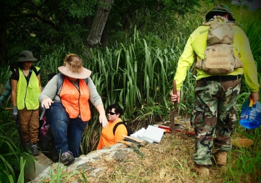
Fig. 4. Field school with UH West O‘ahu: traversing the Honouliuli Gulch to update and map coordinates of World War II–era historical artifacts and cultural features, May–June 2018, Honouliuli National Monument.
Photo composite by the author.
Despite the padlocked gates and restrictions placed on access to this historic landscape, I worked on the grounds of Honouliuli for six weeks as a participant in the summer field school (May–June 2018) run by the University of Hawaiʻi West Oʻahu with the US National Park Service as part of this agency’s partnerships program.17 The field school at Honouliuli involved geolocating the residual material culture of World War II. This required traversing the gulch and following the contours of this sunken landscape (fig. 4). Days were often spent clearing invasive Guinea grass, digging soil pits, and sweeping red dirt to reveal concrete foundations at the various POW, civilian, or military compounds.
Field schools are integral in their role of completing the groundwork to identify, assess, and catalog the conditions of in situ historic objects. My field school colleagues, many of whom were aspiring forensic anthropologists, tracked down the remnants and residues of the former internment camp. We affixed geotags and markers to glass bottles, ceramics, and shell crafts while dodging deposits of ambiguous matter with damp, unpleasantly musty odors. Extant architectural features were furred with mold, cloaked in cobwebs, and scarred with rust. Feral pigs, fuzzy caterpillars, and brightly colored spiders scurried alongside us in the Honouliuli Gulch.
We mirrored the landscape’s sedimentary flows as we traversed this concave landform. Each year, a new set of summer field school participants affixed new geotags and markers to these newly designated “historic objects.” Many of these items included liquor bottles, ceramics, and shell crafts from the World War II era (fig. 5). These can hardly be described as in situ, meaning “on site” or “in place.” Rather, these items were dislodged and repositioned by the gulch’s sedimentary flows occurring with flood events. Smaller items were distributed across these grounds and carried by a narrow stream that flows through Honouliuli Gulch, along with erosion and runoff from agricultural, rural, and industrial activities in this watershed.
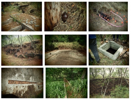
Fig. 5. Extant historical features at Honouliuli National Monument, including concrete compound foundations, drainage catchment structures, retaining walls (low and high), liquor bottles, shell crafts, and ceramics.
Photo taken by the author during field school with UH West O‘ahu, May–June 2018.
Hydrological events like downpours and fast-moving floods set this sedimentary terrain into motion. While concrete foundations remained affixed in this landscape in flux, newly designated historic artifacts moved and descended deeper into the herbaceous understory of invasive grasses as alluvial soils poured into the gulch after heavy rainfalls. This cycle of ebb and flow further conceals these historic objects, mixing with possible pesticide-laden soil in this constantly shifting subterranean landscape. The gulch was a portal into the seasonal and deep-time processes of sedimentation and erosion that set the extant material culture and toxic uncertainties of this landscape into motion.
Yet, conventional strategies for artifact conservation and historic preservation neutralize these natural processes of decay and fail to consider potential or alleged toxicants—their movements in the landscape and their subsequent effect on historic objects. Instead, toxicants are viewed and assessed separately from extant cultural objects, architectural ruins, and historic structures. Ongoing maintenance at Honouliuli prioritizes the documentation and stabilization of wartime cultural resources at Honouliuli National Historic Site at the expense of a longer-storied past and a potentially toxic present. Government documents, reports, and studies tend to be primarily object-focused inventories within a prescribed boundary zone in a predetermined period of significance. This way of documenting the historic landscape remains inattentive to broader chronologies, regional variations, localized histories, and lived experiences in this place. Most importantly, environmental histories of contamination remain outside the purview of cultural landscape assessments and reports. Thus, the unknowability and uncertainty of the toxic present remain further obscured in the historical record.
Soil Horizons: Soil as Archaeological Archive
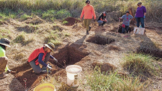
Fig. 6. Soil test pit excavation, UH West O‘ahu field school, Honouliuli National Monument, May–June 2018.
Photo by William Cole, Honolulu Star-Advertiser, taken June 18, 2018, published June 19, 2018.
Forensic landscape archaeology is violent work; holes, cavities, and soil test pits pierce Honouliuli’s ground (fig. 6). Studying soil horizons and taking soil samples are part of making an archive of the land. In Dubravka Sekulić, Milica Tomić, and Philipp Sattler’s account of Aflenz an der Sulm in southern Austria, they position soil as an “active archive” where “repressed memory is deposited in the soil.”18 The authors contend that it “is … important to engage with the knowledge sedimented in the landscape in a continuous cognitive process, especially in a context where there is little political will to deal with the troubled past.”19 In other words, soil offers insight not only into the history of a landscape but also the present in the aftermath of historical events. Reading soil in this way moves beyond the object-centered focus of preservation. The sediment in the Honouliuli Gulch is mobile and terraqueous and disrupts imaginaries of terra firma and notions of territory as dry, stable, or bounded. While the process of sedimentation describes the geological process of transportation, deposition, and lithification of residues, it still implies a “settling” or hardening into place. Instead, Honouliuli Gulch’s grounds exist in an active state and are animated by cycles of water flow that redistribute and reshuffle “in situ” objects and unknown contaminants.20
Sara Ahmed’s writing connects processes of sedimentation with racial formation, arguing that the “sedimented history” of race is a process of “congealing, a solidifying: a history that becomes concrete, a physical barrier in the present.”21 She argues that “to think of race as a sedimented history is to think of how race matters as matter.”22 Similarly, Tao Leigh Goffe, in her study of the relationships between guano and Asian indenture through the materiality of bedrock, contends that “racial sedimentation” or “sedimentation [is] a model for imagining histories of relation and transformation in intimate connection to the land.”23 Thus, while Honouliuli Gulch features uncertain toxicities, it also bears witness to the residues of Asian racialization and plantation histories of indentured labor and wartime incarceration, as they intersect at this very location.
Seth Denizen, a geographer and designer, is one of the landscape architects who “think through soil.” From his research and design studios in the Mexico City–Mezquital Valley system, he suggests that soil offers an important entry point into the study of wastewater agriculture. He shows how soil is useful as an interpretive category with which to study political consequences, design epistemology, and the material contingency of the urban environment.24 Landscape architect Anita Bakshi similarly considers soil as an archive, which can warn of the “deceptive tranquility of contaminated landscapes”; unearthing this history requires, as she argues, a need to “develop the skills to see what hides beneath the logics of its representation.”25 Both Denizen and Bakshi consider soil and contaminants as active historical agents in their landscape representations of ecological systems.
Two other scholars inform my initial thoughts on soil, racial sedimentation, and contamination at Honouliuli. In her satirical work, Hot Spotter’s Report: Military Fables of Toxic Waste (2013), geographer Shiloh Krupar considers the voids in the public record as contaminated sites are capped and reconverted to national wildlife refuges.26 She conjures up “fables” that satirize government cleanup reports to creatively speculate how toxicity is naturalized in soil, drawing attention to how human relations are limited in postmilitary and postnuclear sites, while wildlife and other more-than-human forms returning to these places are celebrated through nationalist narratives of ecological recovery. More recently, the ongoing “disabled ecologies” research of Sunaura Taylor, a disability activist and academic, offers a critical analysis of property designations that devalue land through classifications of “impairment.”27 Here, the language of disability, injury, and disease is applied to ecosystems that are abandoned as “sacrifice zones” and denied an ethics of care.28 Her work on “speculative aquifers,” which features a series of watercolors and sketches of a contaminated aquifer in Tucson, Arizona, is particularly instructive for thinking about landscape representation of harmed environments through the lens of disability.
Collectively, these perspectives (Sekulić et al., Ahmed, Goffe, Denizen, Bakshi, Krupar, and Taylor) serve as a reminder that soil is a medium through which complex fictions of settler colonialism manifest. Recent work on volumetric geographies opens new horizons for studying the exercise of power, property, and landownership on the island. Thinking like a gulch through concepts of verticality, subsurfaces, and sedimentation reveals how present-day governance and ownership structures converge and operate. The normative ideologies, settler narratives, and sociopolitical structures that are involved in the production of toxicity offer valuable insight into the diffuse and relational colonial logics that operate at the level of soil in gulch landscapes and in their broader watersheds. This way of thinking across voluminous terrain captures how regional sociocultural beliefs and attitudes toward land, property, and uncertain toxicities collide and are subsequently obscured in the formation of national heritage making.
“Taming the Memoryscape”: Wartime Waste and Heritage
The material legacies of the Pacific War, as exemplified by Honouliuli and the nearby popular tourist site Pearl Harbor, occupy hybrid categories of toxic waste and heritage. Their supposed illegibility presents challenges that require a new set of spatial strategies akin to those that Asian American studies scholar Lisa Yoneyama terms “taming the memoryscape.”29 She uses this term to describe how affective discourse of wartime harm is subdued or recast.30 Her use of the phrase “taming the memoryscape” refers to the management of the postnuclear landscape of Hiroshima, where war memory, contaminants, and toxins are managed through state-led tours and national narratives. Yoneyama explains that the dominant process of spatial containment defines the proper territories for memorializing by prescribing whose experiences should be remembered and when, where, and how they should be invoked.
It is unclear how Honouliuli, when it finally opens to the public, will operate in tandem with its partner heritage site, the Pearl Harbor National Memorial.31 Both places are designated federal or public lands and are owned and managed by the National Park Service.32 Both of these sunken or partially submerged sites commemorate Pacific War history, and both locations were designated sites of national significance, in 2008 and 2015, respectively, via the presidential powers of the Antiquities Act of 1906.33 The adjacent Pearl Harbor Naval Complex, which includes the National Memorial, is an active military facility and was listed as a Superfund site in 1992.34 To date, there are three active Superfund sites on the island of Oʻahu: Pearl Harbor, the Naval Computer and Telecommunications Area, and the Del Monte Corp. (formerly Oahu Plantation), slightly north of the present-day Honouliuli National Heritage Site.
Ultimately, the protection and interpretation of Pacific War heritage demand a more robust interrogation of the ways that these places perpetuate continuous occupation and contamination in these current and former US possessions and territories. The silence and secrecy around federal land acquisition, through preservation and for military purposes, naturalizes the ongoing appropriation of Indigenous land while evading long-standing local movements on the island of Oʻahu for demilitarization, decontamination, and sovereignty. At the scale of the Honouliuli Gulch, it is crucial to acknowledge the distinct history of illegal takeover, annexation, statehood, and ongoing occupation in Hawaiʻi that has long dispossessed and severed Kānaka Maoli stewardship from select lands and waters on the island.35 This multiscalar site thus requires alternate modes of preservation and landscape remediation that pay attention to its sediments’ toxic uncertainties and the legacy of land dispossession that remain concealed at Honouliuli National Historic Site.
✓ Transparent peer-reviewed
Desirée Valadares, “Thinking Like a Gulch: Pacific War Heritage, Settler Lands, and Subsurface Toxic Uncertainties in Oʻahu,” Aggregate 11 (May 2023), https://doi.org/10.53965/BJTM8353.
- 1
See Heidi Scott, “Colonialism, Landscape, and the Subterranean,” Geography Compass 2, no. 6 (2008): 1853–69; Middleground: Siting Dispossession, exhibition presented by the Canadian Centre for Architecture, Montreal, February 10, 2021–March 13, 2022; Maria de Lourdes Melo Zurita, Paul George Munro, and Donna Houston, “Un-earthing the Subterranean Anthropocene,” Area 50, no. 3 (2017): 298–305; and Rachel Squire and Klaus Dodds, introduction to “Subterranean Geopolitics,” special issue, Geopolitics 25, no. 1 (2020): 4–16.
↑ - 2
For example, Stuart Elden’s article “Secure the Volume” and, more recently, cultural anthropologist/geographer Franck Billé’s edited volume Voluminous States argue for the necessity of rethinking geography in terms of volume rather than area. This growing body of literature collectively argues that space is voluminous, multiplicitous, and heterogenous. See Stuart Elden, “Secure the Volume: Vertical Geopolitics and the Depth of Power,” Political Geography 34 (May 2013): 35–51; Franck Billé, introduction to Voluminous States: Sovereignty, Materiality, and the Territorial Imagination, edited by Stuart Elden (Durham, NC: Duke University Press, 2020), 1–35; Chi-Mao Wang, “Securing the Subterranean Volumes: Geometrics, Land Subsidence and the Materialities of Things,” Environment and Planning D: Society and Space 39, no. 2 (2021): 218–36; Franck Billé, “Volumetric Sovereignty,” Society and Space, October 24, 2017, https://www.societyandspace.org/forums/volumetric-sovereignty; and Franck Billé, “Speaking Volumes,” Editors’ Forum, Cultural Anthropology, June 27, 2018, https://culanth.org/fieldsights/series/speaking-volumes.
↑ - 3
See Macarena Gómez-Barris, “Submerged Perspectives: The Arts of Land and Water Defense,” Globalizations 18, no. 6 (2021): 854–63; and Macarena Gómez-Barris, “Below the Surface” and “Submerged Perspectives,” in The Extractive Zone: Social Ecologies and Decolonial Perspectives (Durham, NC: Duke University Press, 2017), xiii–xx and 1–16.
↑ - 4
Brandy Nālani McDougall, “Water Remembers,” Journal: The Missing Slate, October 1, 2017, http://journal.themissingslate.com/2017/10/01/water-remembers/.
↑ - 5
Cathy Song, “Leaving,” from Picture Bride (New Haven: Yale University Press, 1983), accessed at the Poetry Foundation, https://www.poetryfoundation.org/poems/43363/leaving-56d222187f6d0.
↑ - 6
For background on the ancestral ahupuaʻa system in the Hawaiian Kingdom, see Jon van Dyke, Who Owns the Crown Lands of Hawaiʻi? (Honolulu: University of Hawaiʻi Press, 2007); Candace Fujikane and Jonathan Okamura, Asian Settler Colonialism: From Local Governance to the Everyday Habits of Hawaiʻi (Honolulu: University of Hawaiʻi Press, 2008); Katrina-Ann R. Kapāʻanaokalāokeola Nākoa Oliveira, Ancestral Places: Understanding Kānaka Geographies (Corvallis: Oregon State University Press, 2014); Erin Kahunawaikaʻala Wright, Ikaika Hussey, Noelani Goodyear-Kaʻōpua, A Nation Rising: Hawaiian Movements for Life, Land, and Sovereignty (Durham, NC: Duke University Press, 2014); Katrina-Ann R. Kapāʻanaokalāokeola Nākoa Oliveira and Erin Kahunawaikaʻala Wright, eds., Kānaka ʻŌiwi Methodologies: Mo’olelo and Metaphor (Honolulu: University of Hawaiʻi Press, 2015); David Chang, The World and All the Things Upon It: Native Hawaiian Geographies of Exploration (Minneapolis: University of Minnesota Press, 2016); Karen E. Ingersoll, Waves of Knowing: A Seascape Epistemology (Durham, NC: Duke University Press, 2016); J. Kēhaulani Kauanui, Paradoxes of Hawaiian Sovereignty: Land, Sex, and the Politics of State Nationalism (Durham, NC: Duke University Press, 2018); Patrick Vinton Kirch, A Shark Going Inland Is My Chief: The Island Civilization of Ancient Hawaiʻi (Oakland: University of California Press, 2019); Hokulani K. Aikau and Vernadette Vicuña Gonzalez, Detours: A Decolonial Guide to Hawaiʻi (Durham, NC: Duke University Press, 2019); Candace Fujikane, Mapping Abundance for a Planetary Future: Kānaka Maoli and Critical Settler Cartographies of Hawaiʻi (Durham, NC: Duke University Press, 2021).
↑ - 7
See Carol A. MacLennan, Sovereign Sugar: Industry and Environment in Hawaiʻi (Honolulu: University of Hawaiʻi Press, 2014); Allan Jones and Robert Osgood, From King Cane to the Last Sugar Mill: Agricultural Technology and the Making of Hawaiʻi’s Premier Crop (Honolulu: University of Hawaiʻi Press, 2015); Carol Wilcox, Sugar Water: Hawaiʻi’s Plantation Ditches (Honolulu: University of Hawaiʻi Press, 1997); Ronald Takaki, Pau Hana: Plantation Life and Labor in Hawaiʻi, 1835–1920 (Honolulu: University of Hawaiʻi Press, 1983); Chennat Gopalakrishnan, “The Politics of Water in Hawaiʻi: An Institutional Appraisal,” International Journal of Water Resources Development 12, no. 3 (1996): 297–310; and Mark D. McCoy and Michael W. Graves, “The Role of Agricultural Innovation on Pacific Islands: A Case Study from Hawaiʻi Island,” World Archaeology 42, no. 1 (2010): 90–107.
↑ - 8
Lawrence Kessler, “After the Plantations: The Past and Future of Agriculture in Hawaiʻi,” Solutions Journal, January 13, 2017, https://issuu.com/thesolutionsjournaldigital/docs/his_kessler.
↑ - 9
US Environmental Protection Agency, Defueling Plan and Closure of the Red Hill Bulk Fuel Storage Facility, accessed September 2022, https://www.epa.gov/red-hill/defueling-plan-and-closure-red-hill-bulk-fuel-storage-facility.
↑ - 10
Mary M. Farrell, Honouliuli POW and Internment Camp: Archaeological Investigations at Jigoku-Dani 2006–2017 (Honolulu: Japanese Cultural Center of Hawaiʻi, 2017), 37.
↑ - 11
National Park Service, Foundation Document, Honouliuli National Historic Site, Hawaiʻi, National Park Service, US Department of the Interior, 2019, 29.
↑ - 12
Office of the Press Secretary, the White House, “Presidential Proclamation—Establishment of the Honouliuli National Monument,” February 24, 2015, https://obamawhitehouse.archives.gov/the-press-office/2015/02/24/presidential-proclamation-establishment-honouliuli-national-monument.
↑ - 13
In its final form, the Antiquities Act of 1906 includes three sections. Section I prohibits the excavation or removal of ancient items from public land without permission. It also imposes limits on a host of potentially damaging activities, such as mining, homesteading, grazing and logging. The second section of the law authorizes the president to establish or, in the terminology of the act, “to declare by public proclamation” national monuments and reserve them for proper care and management. Section III allows for the “relinquishing of these lands” for protection under federal services.
↑ - 14
Following the closure of the Honouliuli POW and civilian internment camp in 1946, the land was leased by the Oahu Sugar Company from the Campbell estate and sugarcane was grown on adjacent lands. In 2007, Monsanto purchased the land on which the parcel of Honouliuli sits. Prior to the site’s designation, landowner Monsanto donated 143 acres of farmland to the federal government.
↑ - 15
For a comprehensive history of the use of the Antiquities Act, see David Harmon, Francis P. McManamon, and Dwight T. Pitcaithley, The Antiquities Act: A Century of American Archaeology, Historic Preservation, and Nature Conservation (Tucson: University of Arizona Press, 2006).
↑ - 16
See US Department of Justice, “Monsanto Agrees to Plead Guilty to Illegally Using Pesticide at Corn Growing Fields in Hawaii and to Pay Additional $12 Million,” news release no. 21-254, December 9, 2021, https://www.justice.gov/usao-cdca/pr/monsanto-agrees-plead-guilty-illegally-using-pesticide-corn-growing-fields-hawaii-and.
↑ - 17
In a forthcoming piece on fieldwork, I reflect on my own fraught position as an (international) student who has the privilege of gaining access to these lands under the guise of “educational training.”
↑ - 18
Dubravka Sekulić, Milica Tomić, and Philipp Sattler, “Digging Up the Past: Soil as Archive,” Architectural Review, February 12, 2020, https://www.architectural-review.com/essays/digging-up-the-past-soil-as-archive.
↑ - 19
Sekulić et al., “Digging Up the Past.”
↑ - 20
For studies on geosocial readings of sedimentary politics, see Lindsay Bremner, “Sedimentary Logics and the Rohingya Refugee Camps in Bangladesh,” Political Geography 77 (March 2020), https://doi.org/10.1016/j.polgeo.2019.102109.
↑ - 21
Sara Ahmed, “Race as Sedimented History,” Postmedieval: A Journal of Medieval Cultural Studies 6, no. 1 (2015): 95.
↑ - 22
Ahmed, “Race as Sedimented History,” 95.
↑ - 23
Tao Leigh Goffe, “Guano in Their Destiny: Race, Geology, and a Philosophy of Indenture,” Amerasia Journal 45, no. 1 (2019): 32.
↑ - 24
Seth Denizen, “DES 3385: Thinking through Soil,” GSD, Harvard University, Spring 2020, https://thinkingthroughsoil.studio/About.
↑ - 25
Anita Bakshi, “Contaminated Representations,” e-flux Architecture, October 2020, https://www.e-flux.com/architecture/the-settler-colonial-present/352059/contaminated-representations/.
↑ - 26
Shiloh R. Krupar, Hot Spotter’s Report: Military Fables of Toxic Waste (Minneapolis: University of Minnesota Press, 2013). See also Shiloh R. Krupar, “Alien Still Life: Distilling the Toxic Logics of the Rocky Flats National Wildlife Refuge,” Environment and Planning D: Society and Space 29, no. 2 (2011): 268–90; Jennifer Gabrys, “Sink: The Dirt of Systems,” Environment and Planning D: Society and Space 27, no. 4 (2009): 666–81, https://doi.org/10.1068/d5708; Shiloh R. Krupar, “Where Eagles Dare: An Ethno-Fable with Personal Landfill,” Environment and Planning D: Society and Space 25, no. 2 (2007): 194–212, https://doi.org/10.1068/d4505.
↑ - 27
Sunaura Taylor, “Keynote Lecture—Disabled Ecologies: Living with Impaired Landscapes and Crip Ecologies: Vulnerable Bodies in a Toxic Landscape,” Art Gallery of Windsor; Tangled Art + Disability; Health Equity and Social Inclusion Interdisciplinary Research Group, University of Windsor, 2022.
↑ - 28
Sunaura Taylor, Speculative Aquifers, Efa Project Space, 2019, https://www.projectspace-efanyc.org/sunaura-taylor.
↑ - 29
“Taming the memoryscape” refers to a chapter in Hiroshima Traces whereby scholar Lisa Yoneyama explains that the reformulated cityspace of Hiroshima provides a new “container of power.” See Lisa Yoneyama, Hiroshima Traces: Time, Space and the Dialectics of Memory (Berkeley: University of California Press, 1999). For more on conversion ecologies of former war landscapes, see Lisa Benton-Short, The Presidio: From Army Post to National Park (Boston: Northeastern University Press, 1998); Greig Crysler, “Groundwork: (De)Touring Treasure Island’s Toxic History,” in Urban Reinventions: San Francisco’s Treasure Island, ed. Lynne Horiuchi and Tanu Sankalia (Honolulu: University of Hawaiʻi Press, 2017), 229–60; and Krupar, Hot Spotter’s Report: Military Fables of Toxic Waste.
↑ - 30
See Yoneyama, Hiroshima Traces.
↑ - 31
In 2019, Honouliuli and Pearl Harbor were renamed and elevated from national monument status to national historic site and national memorial, respectively. This change occurred due to an omnibus lands act—the John D. Dingell Jr. Conservation, Management, and Recreation Act—that modified management provisions for existing public lands.
↑ - 32
Both President George W. Bush and President Barack Obama wielded the executive powers of the Antiquities Act of 1906 to declare the detritus of World War II as national heritage. President Bush designated the Pearl Harbor unit of the World War II Valor in the Pacific National Monument in 2008 and President Obama designated Honouliuli National Monument in 2015.
↑ - 33
The relatively recent recovery and commemoration of Honouliuli National Historic Site stands in stark contrast to other Pacific wartime sites of national heritage that valorize heroic military encounters and events. Honouliuli is distinct since it offers a narrative of the selective wartime internment of Hawaiʻi’s civilian Japanese community. Furthermore, the then-territory status of Hawaiʻi and the history of US martial law provide an alternative story to the dominant US mainland West Coast narrative of Japanese American civilian internment under Executive Order 9066. Honouliuli’s inclusion in the corpus of US heritage demonstrates how emergency laws during wartime, pertaining to national defense and security, were not pursued uniformly within national borders during World War II.
↑ - 34
The Comprehensive Environmental Response, Compensation and Liability Act (CERCLA) of 1980 was the environmental law that authorized the US Environmental Protection Agency (EPA) to create a list of priority locations known as Superfund sites, which are placed on the National Priorities List (NPL). The Pearl Harbor Naval Complex was listed due to the presence of petroleum hydrocarbons, metals, and organic compounds in the soil, groundwater, and sediment.
↑ - 35
For critiques of land management, US statehood, and military occupation, see George Cooper and Gavan Daws, Land and Power in Hawaii: The Democratic Years (Honolulu: University of Hawaiʻi Press, 1990); Greg Dvorak, “Oceanizing American Studies,” American Quarterly 67, no. 3 (2015): 609–17; Craig Santos Perez, “Transterritorial Currents and the Imperial Terripelago,” American Quarterly 67, no. 3 (2015): 619–24; Laurel Mei-Singh, “Carceral Conservationism: Contested Landscapes and the Ecologies of Dispossession at Kaʻena Point, Hawaiʻi,” American Quarterly 68, no. 3 (2016): 695–721; Catherine Lutz, The Bases of Empire: The Global Struggle against U.S. Military Posts (New York: New York University Press, 2009); and Dean Itsuji Saranillio, Unsustainable Empire: Alternative Histories of Hawai’i Statehood (Durham, NC: Duke University Press, 2018).
↑